
I got a once-in-a-lifetime chance to hike to The Wave. Only 64 people are permitted to hike there every day, it’s the only legal lottery in Utah! And yes, it looks just as amazing as in photos.

A few months back I finished these two paintings of Babylon Arch and Lower Calf Creek Falls. Both of these beautiful spots are in southern Utah and they are seriously two my all-time favorite hikes in Utah.
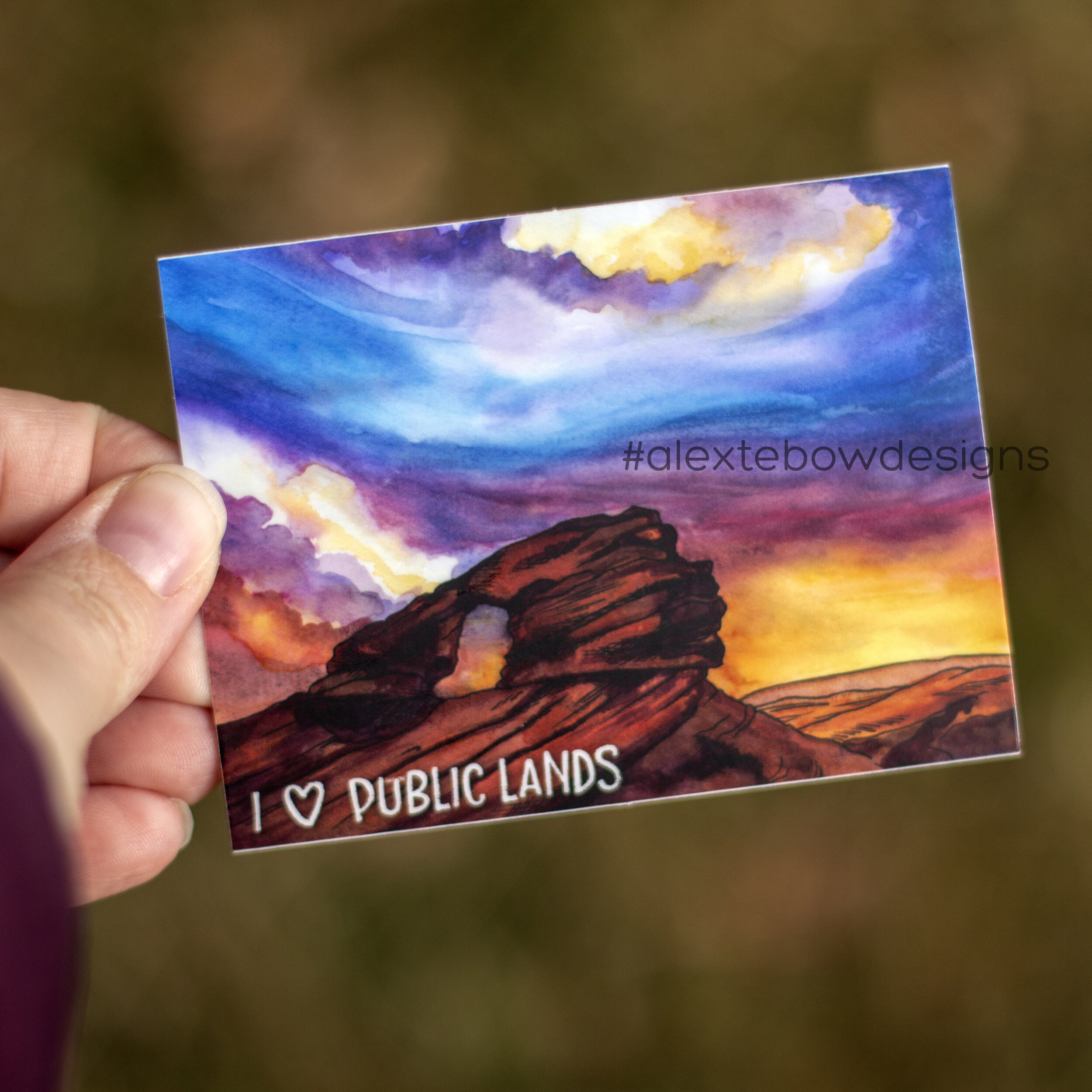
Babylon Arch is near Hurricane, UT and is part of the Red Cliffs National Conservation Area. It’s a beautiful hike through some little canyons and you get a beautiful view of the Virgin River before descending a sandy slope to the arch. Late afternoon is a wonderful time to go for some really amazing light.
If you’d like to purchase a sticker of this artwork, click here!


Lower Calf Creek Falls is in southern Utah too, but closer to Boulder and Bryce Canyon National Park. As the crow flies, it’s about halfway between Bryce Canyon and Capitol Reef National Parks. It’s a really wonderful hike through a small canyon and along a creek. There are sections that are loose sand, and the hike is a bit long for kids at about 6.5 miles roundtrip. But the waterfall at the end is so worth it! You can even find thousand-year-old pictographs on a canyon wall. In the summer I bet it’s very hot, but you can swim in the icy water. We hiked in early April, so it was warm enough to enjoy the water on our tired feet, but still cool enough to not be miserable.
If you’d like to purchase a sticker of this artwork, click here!


My kids informed me that my time lapse videos are too short to gain many viewers or subscribers on YouTube, so I combined both of these paintings into one. They can stop giving me crap now.
Materials (many of these are affiliate links):
Daniel Smith Watercolor
Trekell Watercolor Brushes
daVinci Travel Watercolor Brushes
Pocket Palette (x2)
Grumbacher Miskit Masking Fluid
Fluid Cold Press Watercolor Paper
Phone Holder/Ring Light Thingie (quite handy!)
Have any of you been to one or both of these beautiful spots??
I have been struggling to have the motivation to paint the last month or two. I really want to make more paintings that I can turn into stickers and maybe even sell as prints, but motivation just hasn’t been there. My kids are back to attending school in-person too, so it’s not like I don’t have the time. Sometimes it’s kind of like exercise: when I don’t feel like doing it, if I force myself, I feel so much better afterward and feel glad that I pushed myself.

This was my mood the other night, so I made myself a mug of hot tea, put some Star Trek: Discovery on my iPad and set to work on a new painting. I wanted to do another starry night sky, so I chose a mountain that is relatively close to home rather than a spot in southern Utah: Sundial Peak and Lake Blanche. Lake Blanche is in Big Cottonwood Canyon and it’s a hike I really want to do this year. It’s more challenging than ones we’ve done before, so I haven’t been able to go with my kids. I have heard that we can backpack up there too, so I’m going to try and convince my oldest to go backpacking with me up there. The promise of a lake with fish should be enough.
By the way, I bought myself a second Pocket Palette so I can keep my warm and cool colors separate and I am loving it!

I chose not to go over this one with black ink. I felt it really didn’t need it. I also need to stop using blue painter’s tape and get some proper masking tape. I keep having issues with the tape tearing the paper. I’m betting thicker paper may help too.
I don’t know if I will turn this one into a sticker. I like how it turned out, but there are a few tweaks I’d like to make to the colors before I will be happy with making it a sticker. Plus, it’s part of National Forest land, not sure my “I heart public lands” verbiage really works. Should I do something else? Maybe a short quote about wilderness or exploration? I will have to think on it for a bit.
In the meantime, here’s a time lapse of how I made this painting:
By the way, are you following my YouTube channel? If not, here’s the link. My kids keep telling me I need to post more, so I’m working on that. The fact that I have no formal video-editing skills is quite apparent.
Here are the materials I used for this painting (many of these are affiliate links):
Daniel Smith Watercolor
Trekell Watercolor Brushes
daVinci Travel Watercolor Brushes
Pocket Palette (x2)
Grumbacher Miskit Masking Fluid
Fluid Cold Press Watercolor Paper
Phone Holder/Ring Light Thingie (quite handy!)
I never regret forcing myself to paint… but occasionally, I start a painting and never finish. I have a painting started on my desk right now, and I’m not sure if I will finish it. I want to do two more paintings on Utah’s public lands and then I will offer a deal on buying the whole set of stickers. I need to get that finished.
Any suggestions on beautiful spots you’d like to see painted?? I have some ideas saved, but I would love to hear more; even from spots that are not in Utah!
The two newest stickers from my Utah’s Public Lands Series are here and they’re beautiful. Sticker Mule does such a great job with printing them. These two locations are ones that are a couple of my favorite hikes in southern Utah.
Babylon Arch is close-ish to Hurricane, UT and Zion National Park. You meander through sandstone canyons and cliffs and then after a short stumble down a loose sand bar you’re greeted with the beautiful arch and a panoramic view of the Virgin River. It’s so beautiful; especially in the late afternoon with the sun low. Depending on road conditions, you may need a high-clearance vehicle to get to the trailhead though. I haven’t been brave enough to see if my minivan could make it.

Lower Calf Creek Falls is outside of Boulder, UT kind of in between Bryce Canyon and Capitol Reef National Parks. It’s a perfect stop if you’re traveling from one park to the other. It’s a long-ish hike (for kids at least), but it’s not very difficult. It wanders through a canyon, along side a creek, a few spots are sandy. There are trail markers on the way the coordinate with a PDF file that teaches about the canyon itself. There are pictographs on a canyon wall and at the end you’re greeted with a stunning waterfall. In the warmer months hikers can swim in the icy water.

I have seven paintings completed in this Utah’s Public Lands Series and I need to decide where I’m heading next. Should I do a few more and round it out at ten? I have a few more spots I want to paint, I just haven’t been to all of them in person, so I have to rely on the photographs of others to guide me. I really want to do a sticker from Gooseberry Mesa near Hurricane, but I’m still looking for the right photo inspiration. Other spots I have started to investigate include Colonnade Arch near Moab, Moonshine Arch near Vernal, and Buckskin Gulch near Kanab.
Any suggestions or recommendations?
Stickers are here! I have created a handful of watercolor paintings of some beautiful places on Utah’s public and BLM lands and I’ve have them made into stickers. Check them out here!
Alex’s Sticker Store
Here’s a rundown on them:

Two arches from Coyote Gulch in Grand Staircase-Escalante National Monument, near Escalante, UT. I so want to go backpacking there next year!
Pioneer Arch at Pioneer Park and part of the Red Cliffs National Conservation Area. This park is right in St. George, UT and so much fun to play in. Loads of rocks to climb, a slot canyon for kids and thinner adults to shimmy through, and a pioneer cabin to explore.

Fisher Towers near Moab, UT is really stunning. I’ve heard it’s popular among rock climbers too.

This little waterfall lives on the Red Reef Trail inside Red Cliffs National Conservation Area close to Leeds, UT. It’s a fantastic trail any time of the year, but it’s really special when there’s water in the creek. I will probably paint a couple of other spots on this trail too, it’s so beautiful.

Corona Arch near Moab, UT. This arch lives on BLM land right outside the entrance to Arches National Park. I’ve been to Arches twice and haven’t been able to make it to this massive arch. I hope to next year!

Babylon Arch is the most recent sticker that is currently being printed right now. This is easily one of my favorite trails through gorgeous sandstone cliffs and little canyons. And then when you get to the arch, you’re greeted by lovely views of the Virgin River. It’s pretty awesome.
I’m really proud of how well these turned out and I plan to do at least two more to finish the series at eight stickers… or maybe 10. I haven’t decided yet. There is so much public land in Utah, I think I read that almost 40% of the state is public land; mostly in the south and western parts of the state. I’ve lived here nine years and I’ve only seen a fraction of what’s here.
Once I’m done with public lands paintings, I think I’ll move on to my favorite spots within National Parks. Or maybe I’ll do some of Utah’s state parks? I also have been thinking about making a coloring book that showcases my favorite hikes. Any suggestions?
I had a scrap piece of watercolor paper staring at me yesterday and my fingers were itching to paint a starry sky. I have been to Arches National park twice and neither time was I able to explore Corona Arch, which is just outside the park. Maybe next spring??

I was really happy with how it turned out and I realized I was totally channeling another artist I follow; Nikki Frumkin. She paints beautiful landscapes in the PNW. Go check her out: Drawn to High Places. Nikki, you really need to come and explore southern Utah. The contrast of the red and orange rocks is so amazing against a starry sky with blues and purples.

I’m hoping to have a handful of stickers available of my paintings of beautiful spots in Utah’s public lands, so say tuned!!
For anyone interested, here are the materials I used (most of these are affiliate links):
Daniel Smith Watercolor Paints
Pocket Palette from Expeditionary Art
Trekell Watercolor Brushes
daVinci Travel Watercolor Brushes
Grumbacher Masking Fluid
Fluid Cold Press Watercolor Paper
Faber-Castell Pitt Brush Pens
We’re spending a LOT of time at home these days, so of course my desire to be out hiking in our canyons and in the desert is strong! We are on Spring Break this week and our schools have been closed for three weeks already. With our Spring Break travel plans to California canceled because of the Covid-19 virus, I had this inkling of hope that maybe we could escape to the desert instead. Nope! I read a plea from the director of the hospital in Moab and his explanation of how small his hospital is and how it’s not prepared to handle a pandemic AND the number of annual tourists who flock to the area every spring. I understood completely and was not willing to put the small communities in southern Utah at risk of the virus coming with me. Our annual trip to Arches was canceled and spending Spring Break on BLM land outside of Hurricane was done.
Instead, I’m living vicariously through painting. A few months ago I created a painting of Babylon Arch for Shanti and her Hiking My Way Retreats. I loved how it turned out so I decided to think about all of the beautiful landmarks that reside on BLM/public lands and do a series of paintings of them. Maybe I’ll turn them all into stickers one day, I haven’t gone that far yet. Maybe I can donate proceeds to a nonprofit that fights to protect our glorious public lands?
I will eventually do another painting of Babylon Arch (because it’s awesome and so is the surrounding area), but for now I have Fisher Towers, which is outside of Moab, UT:


A little waterfall on the Red Reef Trail in the Red Cliffs National Conservation Area in southwestern Utah:


Both areas are absolutely beautiful to explore. I plan to do another painting from the Red Reef Trail too.
One of my impulse purchases amid this Covid-19 business was a phone holder and light that lets me record time lapse videos of my painting. I learned the very basics of iMovie and, after some coaxing from my 10yo, I started a YouTube channel. Give my channel a visit and maybe a Like here and there.
So far I only have a few videos up there, including a video on how I make Bolognese Lasagne, but I plan to add more in the following weeks.
I’m hoping to get more paintings going, especially since Utah is acting like its normal self in the spring and going back and forth between glorious sunshine and gusting wind and rain; maybe even a little snow.
What are some landmarks on public lands that you think I should do next??